Lessons from the Tohoku-Oki Earthquake
By Eliza Richardson, AGU Seismology Section Secretary and Associate Professor of Geophysics in the Department of Geosciences at Penn State University
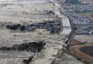
Seven years ago on 11 March 2011, the magnitude 9.0 Tohoku-Oki earthquake ripped hundreds kilometers of fault northeast of the island of Honshu, spawning a 38-meter-high tsunami that devastated a 1000 km-long stretch of coastline that had been described in the 1700s by Bash? as the most beautiful in all Japan (Ehrlich, 2013). The meltdown of the damaged Fukushima Daiichi nuclear reactor further exacerbated what would already have been an incredibly costly rebuilding effort by radioactively contaminating communities and fishing enterprises over a 100 km radius, according to The Economist.
The Tohoku-Oki earthquake is the largest magnitude earthquake to have happened during the lifetimes of most AGU members and certainly the largest to be recorded by the multitude of sensors available to scientists now. Satellites with radar altimeters recorded the height and characteristics of the tsunami, Deep-ocean Assessment and Reporting of Tsunami buoys recorded its passage across the Pacific Basin. Geodetic and seismic stations provided incredible details about the earthquake source itself, raising new questions about slow precursory slip and the rheology of megathrust faults. Fundamental scientific discovery is a mission of AGU, but so is education and outreach. Learning from natural disasters is our obligation both as scientists and citizens of the world.
Japan is arguably one of the best, if not the best, prepared country in the world when it comes to disaster mitigation. More than 20,000 people died, thousands more went missing, but this loss of human life was far less than in the aftermath of the 2004 Sumatra-Andaman earthquake and its resultant tsunami, in which 220,000 people perished according to Munich Re, the leading insurance group on global and local risk solutions. Yet, simple mistakes and poor decisions were still made. The billion-dollar breakwaters constructed offshore were ineffective because they were built with a much smaller maximum wave height in mind. Trees planted on hillsides to slow down waves were washed away (Balcerak, 2011). Community structures built at the ends of long bays in order to be protected from wind-driven waves were much more vulnerable to the tsunami because the geometry of the bay amplifies its waves (Balcerak. 2011). At the Okawa Primary School in Sendai, 74 children and 11 teachers died because they failed to act on the evacuation plans (Parry, 2017).
Are other countries ready to enforce building codes and make effective evacuation plans? How can AGU scientists help? It is important to remember that we are responsible for training and inspiring the next generation of scientists and teachers of science. Therefore, find a way to use the incredibly rich and varied data from this earthquake to create authentic teaching modules at all curriculum levels. Continue the push for more funding for multi-disciplinary approaches to subduction zone science. In addition, AGU members provide an important voice for communicating scientific truths to those who are not scientists, who do not plan to become scientists, yet still need to be savvy consumers of scientific information to make important choices. Let the anniversary of this devastating earthquake remind us of our roles as educators and science communicators even as we pursue deeper understanding of how the Earth works.
****
Balcerak, Ernie, Studies Provide New Insights into Japan’s March 2011 Tsunami,, 2011, EOS v. 92, p. 467.
Ehrlich, Gretel. Facing the Wave: A Journey in the Wake of the Tsunami, Pantheon Books, 2013.
Mission impossible; Fukushima Dai-ichi. The Economist, 7 Feb. 2015, p. 36.
Parry, Richard Lloyd. Ghosts of the Tsunami: Death and Life in Japan’s Disaster Zone. Farrah, Straus and Giroux, 2017.
